N722BD: back-of-the-envelope check of the radar data
N722BD: back-of-the-envelope check of the radar data
Working check — November 1, 2026 accident
Prepared November 3, 2026
STATUS: PROVISIONAL. This is not an official accident reconstruction or a weather forensics report. It reads public radar data at the jet's position and checks it against radar images already in circulation. All times are UTC. Radar reflectivity shows precipitation such as rain, hail and ice, not turbulence or updraft strength, so reflectivity alone does not say what the aircraft encountered inside the storm.
Shared in the hope that it might be found useful as a rough outline. Not a forensic analysis.
Result
- The jet did fly through a strong storm core. Three radars agree on the core's position, and two give about 30–35 dBZ near FL350, above a low-level core in the 50s.
- Entry was at about 17:47:52, give or take several seconds, about 50 seconds after the track began turning toward Freeport.
- The core was about 20 minutes old or older, moving northwest at about 25 kt, with its upper levels strengthening.
- The two circulating images hold up on the main points. Their main difference, storm tops, looks like a matter of threshold and method.
What the radar actually measures
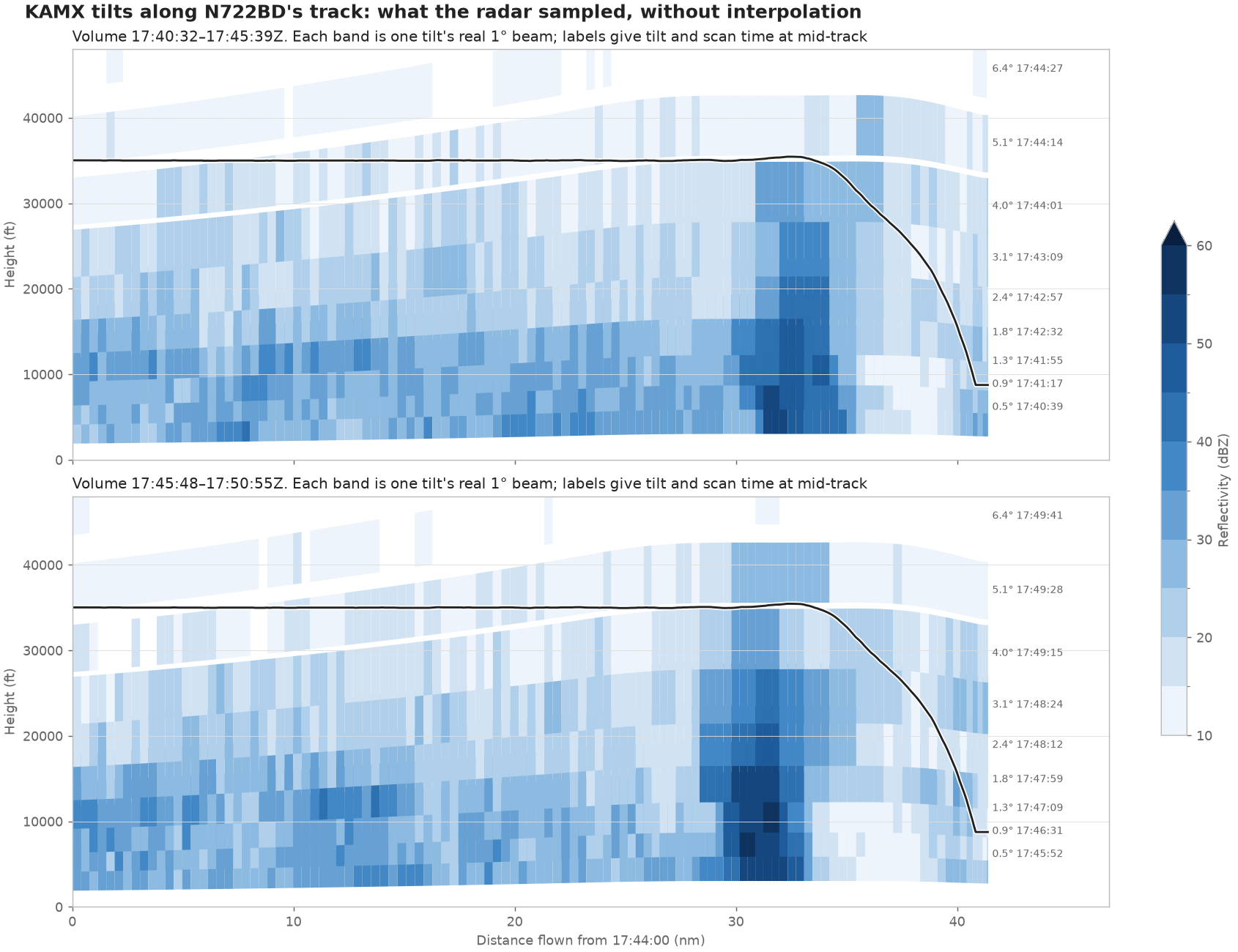
A weather radar does not scan vertical slices. It spins at a series of tilt angles, and each tilt sweeps a cone. A side view has to be cut through those cones.
The strength values along each beam are real. Anything smooth between tilts is interpolated. Two limits matter here:
- Height is coarse. The jet was about 124 km from the Miami radar (KAMX), where a 1° beam is about 7,000 ft tall.
- A column is not a snapshot. One full KAMX scan takes about 5 minutes, and the tilts reach the same point at different times.
This table shows KAMX's scan starting at 17:45:48, at the jet's 17:48:07 position (35,220 ft):
| Tilt | Beam center | Scanned here at | dBZ at nearest gate | Max within 1.5 km |
|---|---|---|---|---|
| 1.8° | 15,531 ft | 17:47:59 | 52.0 | 58.0 |
| 2.4° | 20,200 ft | 17:48:12 | 49.0 | 53.0 |
| 3.1° | 24,613 ft | 17:48:24 | 43.5 | 50.0 |
| 4.0° | 31,155 ft | 17:49:16 | 35.5 | 42.0 |
| 5.1° | 39,324 ft | 17:49:29 | 30.5 | 34.0 |
| 6.4° | 48,442 ft | 17:49:41 | none | 7.5 |
So no KAMX beam was centered on the jet's altitude. The readings on either side were taken about 70–85 seconds after the jet passed this point, shortly before the estimated impact. Any "dBZ at FL350" from this radar is interpolated, and measured after the fact. At this core's speed of about 0.4 nm per minute, it would have moved about 0.5 nm in that time, so the location holds up better than the exact value.
Side view of the tilts, with no interpolation:
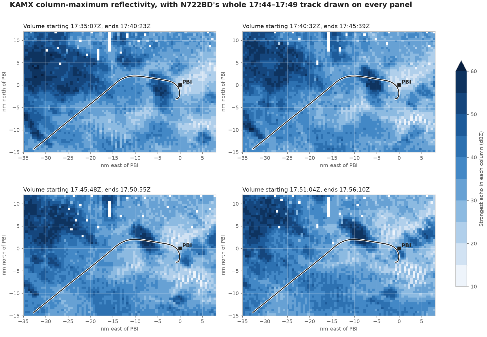
Top-down view, showing the strongest echo in each column:
The jet's encounter with the core
Interpolating between KAMX tilts to the jet's altitude gives:
| Time | Jet altitude | Reflectivity at jet altitude |
|---|---|---|
| 17:47:15 | 34,950 ft | about 12 dBZ |
| 17:47:30 | 34,950 ft | about 14 dBZ |
| 17:47:45 | 35,075 ft | about 20 dBZ |
| 17:48:00 | 35,075 ft | about 31 dBZ |
| 17:48:15 | 35,450 ft | about 25 dBZ |
| 17:48:30 | 34,341 ft | about 19 dBZ |
Reflectivity at the jet's altitude first reaches 30 dBZ at about 17:47:52, and peaks at about 34 dBZ.
Cross-checks from two other radars
The closest radar, the Palm Beach terminal radar (TPBI, about 5 km from the core), has no archived data for this date in the public archive searched. Two others do.
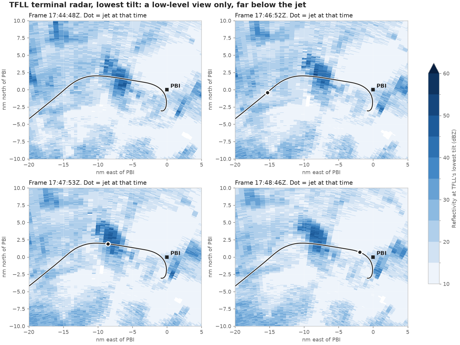
Fort Lauderdale terminal radar (TFLL, about 64 km from the core). Its lowest tilt reaches only about 2,000 ft here, far below the jet, so it checks position and timing, not conditions at altitude. It scans about once a minute. It puts the strongest low-level echo on or just north of the track, about 1.5 nm ahead of the jet's 17:47:53 position, matching KAMX to within about half a mile. Its peak is lower than KAMX's, about 48–50 dBZ. It samples a different height, and its shorter wavelength loses more signal in heavy rain.
Melbourne radar (KMLB, about 160 km from the core). Its beam is wider, but its 3.1° tilt happens to pass near the jet's altitude at this distance, giving a direct reading that needs no interpolation between tilts. These are values at the core-entry point, on scans bracketing the jet's passage:
| Scanned | Beam center | Max within 2.5 km |
|---|---|---|
| 17:44:56 | 33,448 ft | 29.0 dBZ |
| 17:51:37 | 33,852 ft | 35.5 dBZ |
That agrees with KAMX's roughly 30–35 dBZ.
Sequence
This places the ADS-B track and the radio recordings alongside the radar. It is a sequence only. It does not show who chose the route or why, what weather information the crew had, or how the storm looked to them.
| Time | Event | Source |
|---|---|---|
| Before 17:47, time not established | Previous controller approves deviations left or right of course, and "Freeport when able", then hands off to Miami Center on 125.07 | VASAviation compilation, by ear |
| About 17:47:00 | Track begins turning right from about 050° | ADS-B |
| 17:47:03 | Crew checks in with Miami Center, "turning direct Freeport" | LiveATC |
| 17:47:40 | Crew says "we're direct" Freeport | LiveATC |
| 17:47:45–57 | Track about 094–098° | ADS-B |
| 17:47:52 | Reflectivity at jet altitude reaches 30 dBZ | KAMX, interpolated |
| 17:48:00 | Precipitation reported, then climb requested | LiveATC |
| 17:48:29 | Crew reports descending | LiveATC |
LiveATC times assume the archive begins at exactly 17:30:00, as the companion timeline does, and come from machine transcription aligned to the recording. The turn and the check-in fall within a few seconds of each other.
The earlier exchange cannot be placed on this clock. It is not in the LiveATC archive, which first has N722BD at its 17:47:03 check-in, and it comes from an edited compilation with a gap before the check-in. Its audio is poor. It has been checked by ear and against machine transcription, but "Freeport when able" is the likely wording rather than a certain one.
The core over time (rough)
The core is tracked here as the connected area of at least 45 dBZ nearest its previous position, on KAMX's strongest-echo-per-column view with a 0.5 nm grid. These numbers are rough. Cells can merge or split, and the height bands depend on which tilts fall inside them. Position is relative to Palm Beach International (PBI).
| Scan start | Core center (nm east, north of PBI) | Area (sq nm) | Max below 20,000 ft | 20,000–30,000 ft | 30,000–40,000 ft |
|---|---|---|---|---|---|
| 17:24:34 | −0.5, −5.5 | 9 | 51.5 | 37.5 | 19.5 |
| 17:29:50 | −2.3, −3.6 | 10 | 56.0 | 43.5 | 30.5 |
| 17:35:07 | −4.1, −0.9 | 12 | 56.5 | 45.5 | 39.0 |
| 17:40:32 | −5.9, 0.5 | 16 | 58.5 | 54.5 | 40.0 |
| 17:45:48 | −7.5, 2.0 | 17 | 58.5 | 53.0 | 42.0 |
| 17:51:04 | −9.0, 3.1 | 18 | 59.5 | 51.5 | 40.5 |
| 17:56:21 | −10.7, 4.3 | 23 | 56.5 | 49.0 | 37.5 |
Over these 32 minutes the core moved about 2 nm per scan toward the northwest, grew, and strengthened at upper levels until about the time of the accident.
Storm tops
The circulating images give 45,000 and 47,000 ft. This data gives about 41,000 ft at a commonly used 18 dBZ threshold. These can both be right, because KAMX's tilts near the top are widely spaced:
| Threshold | Highest beam center in the core, 17:45:48 scan | Tilt |
|---|---|---|
| 5 dBZ | about 49,400 ft | 6.4° |
| 10 dBZ | about 41,600 ft | 5.1° |
| 18 dBZ | about 40,600 ft | 5.1° |
| 30 dBZ | about 40,600 ft | 5.1° |
No beam was centered between about 41,000 and 48,000 ft, and each beam is itself several thousand feet tall. In the scans before and after, a 10 dBZ echo reached the 6.4° tilt in one (about 46,500 ft) and not the other. So the tops are about 41,000 ft to the high 40s, depending on threshold and method. Gridding smooths across that gap, which likely explains the images' figures, though we have not seen their processing.
The two circulating images
| Claim | @tafische image | livestormchasers.com image | This check |
|---|---|---|---|
| Core entry | 17:47:51 | 17:47:56 | about 17:47:52 |
| Reflectivity at altitude | 25–35 dBZ | 34 dBZ | about 30–35 dBZ |
| Low-level core | darkest shade, 50+ dBZ | 52 dBZ | 50s, up to about 59 |
| Storm tops | about 45,000 ft | about 47,000 ft | about 41,000 ft to high 40s |
| Distance from KAMX | about 110 km | about 75 miles (121 km) | about 124 km |
Both report entry to the second, which this data can't support, for the reasons above. The second image's final quote, "we're out of time", is also more certain than the audio. Carefully, it is "we're out of t[ime]" or similar.
Limitations
- Reflectivity is not turbulence. A 30–35 dBZ reading at altitude does not say how violent the air was. KAMX also records Doppler spectrum width, a rough indicator of turbulence within the beam. A quick look found it elevated in the core but inconclusive, because the beam is about 7,000 ft tall at this range, few comparable cores were close enough to compare, and it did not track the crew's earlier turbulence report, so it is not included here.
- Beam filling and height: a beam thousands of feet tall averages over what it crosses, so small, intense features can be blurred out.
- Timing: KAMX's readings near the jet's altitude came over a minute after the jet passed, and the core was moving.
- Attenuation: heavy rain weakens radar signals, especially at TFLL's shorter wavelength.
- Calibration and processing: values were read directly from the archive, with no quality control or dealiasing, and radars can differ by a few dBZ.
- Altitude: ADS-B altitudes are barometric and radar heights use a standard atmosphere model, so the two don't line up exactly.
Sources
- KAMX and KMLB NEXRAD Level II data, NOAA/Unidata archive: https://unidata-nexrad-level2.s3.amazonaws.com/
- TFLL Level III data (
FLL_TZ0), NOAA/Unidata archive: https://unidata-nexrad-level3.s3.amazonaws.com/ - Flightradar24 granular ADS-B data for N722BD (
Flightradar24_N722BD_Granular_Data.csv). - LiveATC recording
KPBI1-ZMA01-Nov-01-2026-1730Z.mp3. - VASAviation audio compilation, for the exchange before the check-in: https://www.youtube.com/watch?v=v5dfFoZ_fuQ
- Processing: Py-ART (https://arm-doe.github.io/pyart/) and MetPy (https://unidata.github.io/MetPy/).
- Companion documents: N722BD: back-of-the-envelope synchronized ATC / ADS-B timeline and N722BD: back-of-the-envelope speed estimate from dashcam video.